|
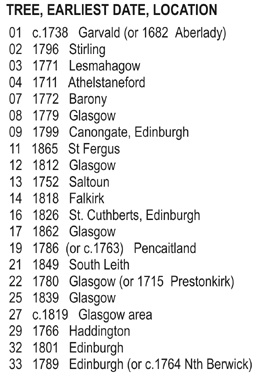
The maps on the following pages show how the Merrilees "look" on the map of Scotland in the years 1600 to 1854, that
is they show the Parish location of baptisms and marriages up to Civil Registration in 1855. There are records before 1600,
but as there are, apparently, so many gaps, it seemed appropriate to omit those. Records are omitted also where a marriage
takes place in one parish and is confirmed in another, these are counted as one event, by the earliest date.
Clearly there are also missing records of marriages and baptisms within the period mapped.
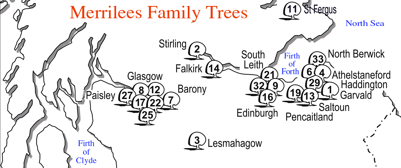
While "Merrilees" evolved as a distinct surname (Mureleis, Mureleyis, Murlie) in West Lothian and Renfrew some time before
1541, by 1600 the family was firmly placed in central and eastern Edinburgh and along the western edge of East Lothian.
Largely, it managed to stay in that heart area.
Some patterns can be seen. Between 1600 and 1650 there are more Merrilees in the Edinburgh area than anywhere else. Towards
1700 and after there was a considerable dispersal eastwards.
Between 1700 and 1750 the greatest number of Merrilees lived in East Lothian, in farming locations and in the villages. Many
of the families were part of that East Lothian dispersal, families came and went through the area, originating in Midlothian
perhaps, moving east, and in another generation going back into Edinburgh and west to the Glasgow/Paisley area and rural Lanarkshire.
In Edinburgh after 1750 the distribution closes in to just five city parishes, which have a high number of families, and at
the same time the population of Merrilees in the Glasgow / Paisley area starts to grow and spread. However between 1800 and 1854
the combined marriages and baptisms of Lanark, Renfrew, Ayr and Dunbarton, at 202, still do not equal in number the Midlothian-East
Lothian total of 243.
This data ends close to the point where Merrilees began seriously to move out of Scotland to America, Canada, Australia, New
Zealand and to all of the other places they went. Mapping the Merrilees for the following fifty years would not give comparable
information.
In a small way the changes form a circle. The last ten locations on my list were, Bonhill 1854, Broughton 1854, Dundee 1854
twice, Liberton 1854, North Berwick 1854, South Leith 1854, and Stirling 1854, 1854, 1854. In counting ten locations the list
just misses the eleventh which is Bo'ness, very close to the Merrylees Cottages where the name possibly began
|